16 of the Best Apps for Landscape Photography
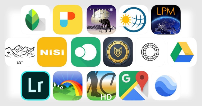
In this article, I’ll share my top 16 favorite apps that I use almost every time I have to plan a photography session, a photo trip, or a complex spot with a long hike in the mountain to get there.
Note: I’m not getting paid by any of these companies to promote their apps. These are simply apps I find useful for my workflow.
Planning
1. Photo Pills
The most complete suite to plan your shooting sessions
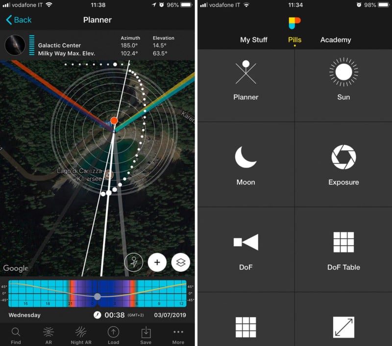
PhotoPills is my favorite app ever. It’s an awesome and very robust app with tons of features, especially for landscape photographers. PhotoPills can help organize your planning, including saving and sharing your plans and managing locations.
You’ll get access to plenty of info about the sun and moon to be in the right place at the right time with just the right lighting. It also includes augmented reality for viewing the position and path of the sun, moon, and Milky Way.
PhotoPills can also help you to calculate exposures, depth of field, and compute the parameters need for time-lapse sequences. This app is a MUST for every landscape photographer, and that’s why it occupies the first place on my personal list of the Best Apps for Landscape Photography!
Download the app: iOS | Android
2. The Photographer’s Ephemeris 3D App
Brings Sun Tracking to a New Dimension
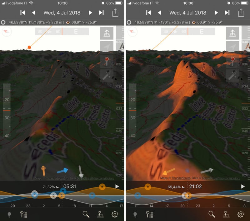
The Photographer’s Ephemeris is a very popular app that allows you to plan landscape photography shots by showing you the position of the sun and moon. The original app allowed you to see the direction of the sun or moon at any point in the day from a given location (more or less the same functionality as Photo Pills). The brand new 3D version is a game changer and it will let you see how the light itself falls onto the topographical landscape.
The Photographer’s Ephemeris 3D, allows users to watch a sunrise or sunset from the future. You can view land anywhere in the world in 3D and watch the light fall onto it as it will in real life. The new app also offers the ability to watch the stars in 3D movement. So, finding the Milky Way and keeping it in your sights will be a breeze. As will tracking sunset shots behind mountains. So in TPE3D you navigate to the area you are interested in by swiping, pinching, etc., and then place a ‘marker’. You can then double-click on the marker to get a view at ground level (and if you’re slightly wrong, you can “walk” your viewpoint around to get a better vantage point).
Along the bottom of the picture, there is a strip that shows the current time, the elevation of the sun and the moon and some markers to show sunrise, sunset, moonrise, etc. You can swipe this left to change the time and the sun will move around in the picture and show the landscape lit correctly including shadows. Absolutely one of the best apps for landscape photography I ever used.
The app is not perfect of course, the detail of the top and overlaid satellite imagery in Google Earth is light years better, but it is not intended to be used in this way. In my view, it is best used when you already have an idea of where you want to shoot, but you want to better visualize how the light will land on the landscape prior to your shoot, or find out exactly where the milky way will be in relation to the landscape. This app has become an indispensable tool in my planning kit, I highly recommend it!
Download the app: iOS
Weather
3. Weather & Radar
Instant weather forecast and rain radar for your location
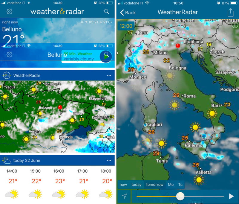
Weather & Radar is one of the most comprehensive free weather apps available. The app delivers current, hourly and 8-day forecasts from million locations around the world. You have an accurate radar, wind, temperature, alerts, pressure, humidity and rain: probability, quantity, duration.
The weather for your location is instantly displayed with the weather forecast, rain radar or weather radar. Looking at the weather forecast for the next hours and days, you can instantly see if there will be rain or sunshine. Swipe to the left underneath the radar to see the weather outlook for the coming hours and days.
The weather radar shows you where the sun is shining at the moment, or where it is cloudy. you can also see where it is raining, snowing or hailing, and where there is currently thunder and lightning. The extensive details provided by the weather radar also include temperature information. Using the search function you can easily find every location and it will automatically be added to your favorites and called up directly. When you tap on the weather radar it will display in a fullscreen view.
Download the app: iOS | Android
4. Light Pollution Map
Locate dark sites where the sky will not be affected by light pollution
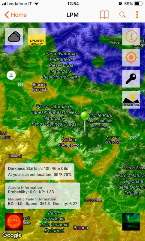
Light Pollution Map allows you to easily locate dark sites where the sky will not be affected by light pollution, allowing the best observance, star gazing, and photography of the night sky.
The map automatically locates you via GPS, and you can find locations with an easy search. Or just look around the map! It’s easy to save your favorite dark sites, just push and hold a spot on the map and click the save button. Is the light pollution map overlay too much? You can adjust the opacity to your liking! The map also features an easy to use legend, so you can be sure you are getting the darkest skies possible for star gazing or night time photography.
Also included is information on the Moon, such as the Moon’s phase, moonrise time, and moonset time! And guess what? That moon information is not only good for the current day but any day in the future!
Note: Free version is ad-supported, has lower resolution/accuracy, and does not allow you to save your favorite locations. Free version also has limited zoom levels. Upgrade to the pro version in-app for a very small fee to remove ads and unlock all pro features.
You have both the desktop and mobile version.
Download the app: iOS | Android
Mountain Identification
5. PeakFinder
The names of all mountains and peaks with a 360° panorama display
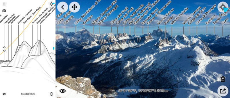
The Dolomites are my favorite place to shoot, and this app helps me to learn step-by-step a lot of the peaks’ names. Peak Finder gives you a 360° panoramic view identifying mountains nearby and further afield (up to 300km). The app works offline with GPS, so no mobile data required. You simply launch the app, point your phone towards your desired direction and Peak Finder will identify the mountains and hills in front of you.
I’ve been using Peak Finder for three years and I’m really impressed. The app fires up quickly and dependent on how fast GPS works on your phone, the app usually finds your location within a few seconds. With all apps that require GPS, occasionally you might have to calibrate your phone.
The rendering of the landscape drawing is sharp and it is easy to pick out mountain peaks and ridges.
Download the app: iOS | Android
Long Exposures and Camera Control
6. NiSi Filters ND Calculator
NiSi Filters App makes it easy to shoot long exposure photography
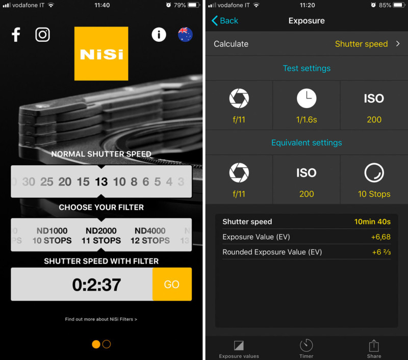
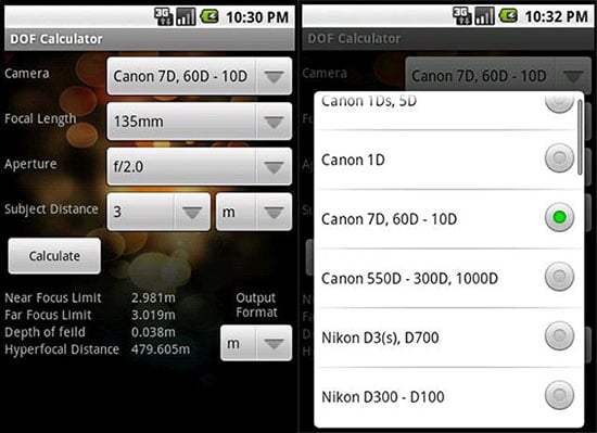
The NiSi Filters ND Calculator App is the most intuitive neutral density calculator I have used. This app is designed to calculate your image exposures. The idea is you can set the shutter speed you’re by a meter reading without any filter on the lens, the ND filter gradation that you are planning to use, and from there you can calculate what the shutter speed would be if you added the ND filter chosen. It’s a very straightforward and very intuitive process.
I could use the specific function within PhotoPills app (below on the right, the interface in PhotoPills), but I prefer the simplicity of the minimalistic controls in the NiSi app and help me to be a bit faster on the field.
Download the app: iOS | Android
7. Cascable 3
The ultimate smartphone camera remote control app
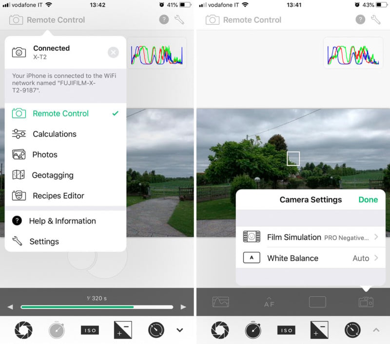
A Wi-Fi–enabled DSLR or mirrorless camera, paired with a smartphone or tablet, offers several advantages, such as wireless transfer of images, the ability to review shots on a screen larger than the LCD on the camera body, remote shutter control, and other features. All of that requires good software, and too often the manufacturer’s efforts are basic or unreliable.
In my case, Fujifilm has a terrible mobile app to control X-Series cameras, bad Wi-Fi connection performance, problems with synching images between camera and smartphone, and so on. Fujifilm, I love your cameras from the bottom of my heart, but what are you waiting to make the app up to expectations?
Cascable 3 (available only for iOS) is the better alternative that adds features many of the camera companies don’t. It’s available for free with a limited but solid set of capabilities. An in-app purchase adds Cascable Pro features.
Even better is the ability to adjust the image settings from the app itself. Tweak shutter speed, aperture, ISO, and exposure compensation using easy to use controls. Tap on the screen to set the camera’s focus point. You can display a live histogram to help you avoid over- or under-exposing areas and a focus peaking option highlights sharp areas in red to aid in getting your focus correct (especially helpful when shooting in the camera’s manual focus mode, although then you need to be near the camera to adjust the lens manually). Definitely one of the best apps for landscape photography.
Download the app: iOS
Image Editing
8. VSCO
A responsive image-editing app with a range of useful tone-adjusting presets and photo sharing community
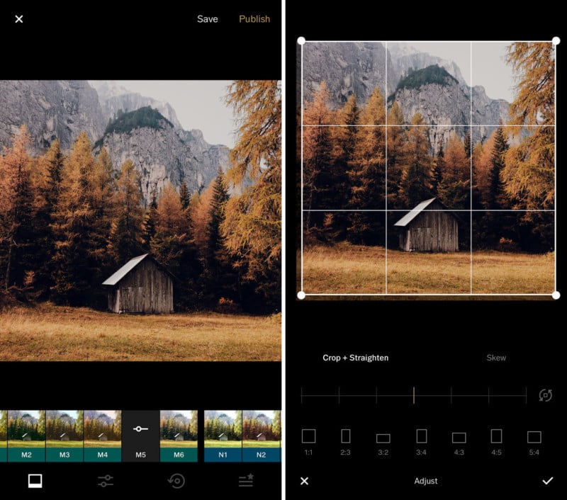
This is the “go-to app” I use to give a look to the BTS shots captured with my smartphone before I share them on social networks like Instagram or Facebook. The user interface of VSCO is very minimal, in spite of having a large number of tools, with a wide range of gorgeous filters inspired by film look. The main menu is easily accessible as you can swipe to the right, across the screen. In this menu, you have access to different features and areas within the app.
The Visual Supply Company is well-known for their sets of Adobe Lightroom presets — for Windows and Mac — that mimic specific kinds of film, like Kodak Portra 160, Fujifilm Xperia 400, and Ilford HP5. Most of the presets in VSCO for iOS have a similar film look, but, unlike the desktop packs, don’t reference specific films. They come in families with cryptic names like M or C — M, VSCO says, is a set of “moody” and “underexposed” filters numbering M1–M3, while C is both “vibrant” and “classic” in C1–C3, and “chromatic” in C4–C9.
C1-C9 and M1-M6 are my favorite series of presets. The first one has a Teal & Orange flavor, while the second one is more suitable for muted tones (like forests, foliage, mountain landscapes, etc…).
VSCO is a brilliant photo editing, sharing and camera app. You can create quality and subtle edits using this app. Even though VSCO camera doesn’t have different modes like the stock iPhone camera app, you still have access to manual features for better control. Also, you have a platform where you can discover and share photos. The community is brilliant and it is a great place to discover new talents and get inspired.
Download the app: iOS | Android
9. Adobe Lightroom CC
The editing solution for the cloud-based workflow
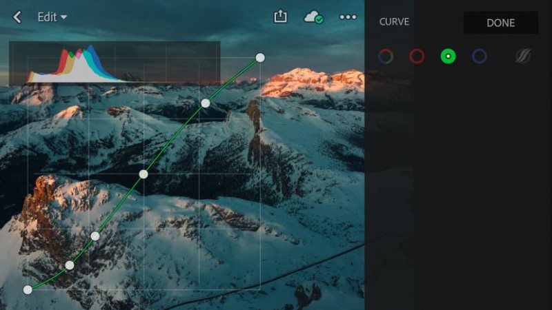
Lightroom CC is a brand new application that works across all platforms: desktop, web, and mobile. The new software offers nearly all of the same editing features we’re used to, but with an entirely new organizational structure reliant upon the cloud. There are so many photo and camera apps, and all work pretty much the same: Take an ordinary smartphone photo and jazz it up with colorful filters. You know the names (in this article I mentioned VSCO and Snapseed).
Lightroom CC takes the darkroom approach to photography. Instead of primarily adding colorful filters to dramatically alter the look of the image, you adjust the things photographers care most about: exposure, shadows, blacks, whites and color balance, as well as cropping, curve adjustments, split toning, HSL color panel.
Editing on the mobile app is free, but you won’t get Adobe Sensei, web galleries and selective editing. But you’ll still get a decent set of high-quality tools for making adjustments, and an app with a superb sense of focus, rather than throwing as many tools at the wall as possible to see what sticks. It comes with 1 terabyte of storage yearly as part of the subscription price.
Download the app: iOS | Android
10. Snapseed
The most powerful and intuitive “On the go photo editing app”
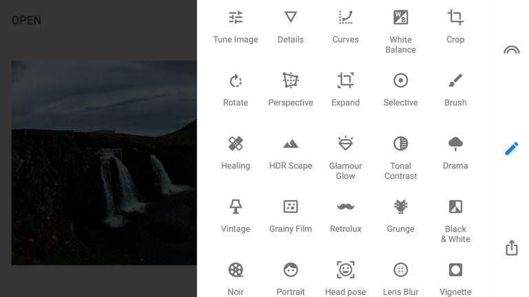
Load a photo into Snapseed and it first resembles any me-too one-click filter tool, with you prodding a thumbnail to update the look of your pic. And even if that’s all you download it for, it’s a good choice, because the presets are pretty great. As an editor, Snapseed excels. The range of tools is wide, covering the basics (tune, crop, rotate, heal and vignette), adding pro-level stuff (curves, DNG support, precision masking, perspective), and enabling you to be properly creative (double exposure, frames, text and grunge overlays).
Working with tools is wonderfully tactile, with you dragging up and down to select a property and then left or right to adjust an effect’s strength. Best of all, you can visit your edit stack and amend any of your previous steps at any point – everything you do in Snapseed is non-destructive. The big plus over Lightroom CC, it’s totally FREE!
Download the app: iOS | Android
GPS Tracking
11. GPSies
Countless routes for all sorts of Outdoor activities
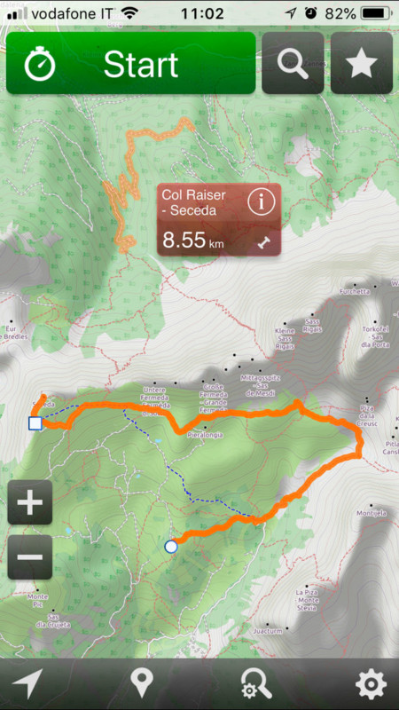
What makes this app one of the best apps for landscape photography? GPSies lists countless routes for all sorts of Outdoor activities. Using various search parameters of the request, the tour can gradually narrow down. In the App, the selected path is displayed in color, and the Track appears in a different color.
The great, free tour community GPSies has provided for each of the matching Track to bearing, he invested a little time in the search.
With GPSies you can view and download tracks which have been recorded by a GPS device. Whether you are searching for running courses or hiking tracks, with GPSies you can see what tracks others have recorded. And you can download all the tracks and put them onto your GPS device so you won’t lose your way.
It’s a very useful app when I have to scout some location in the Dolomites or difficult spots where a mid-long hiking is needed.
Download the app: iOS | Android
12. Terra Map
The best hiking app all around. Find trails, plot routes, and download info for offline use
Why it’s on my personal list of the Best Apps for Landscape Photography? Terra Map is the app to satisfy all my hiking’s needs. You will be able to download the best topo maps and enjoy your new outdoor season. Press the RECORD button, put the phone in your pocket and record your day. Amazingly clear maps, thanks to the Retina technology usage. Easy to use user interface. You can download maps (for FREE, no additional purchase is required) on the device, to be used later without any internet connection. Topo Maps for US, Canada, Europe, South America, Asia, Africa, Oceania (the whole world.).
Share tracks, tours, markers and photos in various formats (KMZ, KML, GPX). Share your track together with all the photo taken along in one single file. Store an unlimited number of tracks, tours, and markers. Optimized battery usage with battery monitoring. Store your track without the need for cellular data or phone signal. Customize your Marker’s icon and Track’s color. Switch between Map display modes (Offline, Satellite, Roads) and different map coloring. Customize the map selecting the information to be displayed. Measure distances on the map. Load any track, tour and marker from internet communities (KMZ, KML, GPX even if zipped). Search objects around you and around a point selected on the map. Search world places by name. Graph of the elevation profile. Graph of speed and pace.
The new mode will greatly extend your display; you will have the details you need for a safe navigation seamlessly integrated with a large overview area. Using this new mode you will see a map 64 times larger than the standard mode without losing any detail in the center part of the screen. Terra Map lets you download for FREE the best topo maps with elevation contours, trails, huts, parks, etc.and all it is necessary to enjoy your best outdoor experience and no additional purchase is required. You can download the maps at home within your device and then use them without any Internet connection need.
The effective battery duration depends on the battery condition, the temperature, other apps currently running in background mode, and the device usage. Like any GPS, the signal quality can vary very much depending on the amount of visible sky, foliage, weather condition, etc. GPS is not reliable indoors. The continuous GPS usage, also in the background, can drastically reduce the battery life.
Download the app: iOS | Android
Geotagging and Location Scouting
13. Google Maps
The free app-based GPS navigation with its robust location database and smooth interface
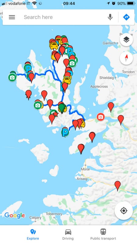
No matter if you’re planning your next photo road trip or you’re scouring the city streets looking for the perfect viewpoint, Google Maps is the most valuable tool to add to your arsenal for finding the perfect photography location.
While planning a trip from home, you have much more time to explore the area in a virtual capacity instead of being out there with boots on the ground. Nothing can compare with actually being there, but the tools available to you are getting better every day and the ability to nearly frame your shot is a real time saver. Time to turn the volume on your pre-visualization up to 11. It may seem obvious, but for me, Google Maps App is without any doubt one of the apps for landscape photography and I couldn’t live without it.
Another incredible tool integrated into Google Maps is My Maps that enables users to create custom maps for personal use or sharing. I can add points, lines, and shapes on top of Google Maps. Moreover, I can also have layers and customize the items in each layer with uniform styles and having labels for the name or description. There are many different objects you can have as your points, such as the town point, accommodation point, bus point, car park or a hut points. You can change the color of anything and change the thickness as well.
Download the app: iOS | Android
14. Google Earth
Fly over a virtual globe and view the Earth through high-resolution graphics and satellite images
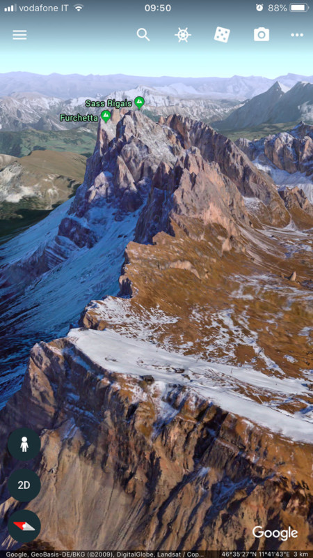
Good old Google Earth. If you’ve spent any time near a computer in the last decade or so you’ve probably played with Google Earth, but did you also know you can also use it on your phone?
Google Earth is an incredibly useful tool for scouting out locations from afar. It allows you to easily see buildings, geological features, and other areas that might be of interest to you in planning a shoot. Google Earth uses a very simple interface that you’re probably already familiar with. There’s not much of a learning curve here. Just download the app, start getting the lay of the land, and get ready to shoot away.
I would typically use Photo Pills in conjunction with Google Earth to understand how the light and shadows would look on the mountains, but Google Earth’s representation leaves something to be desired as well. Anyway, it’s a fantastic tool that I love to use and which is a perfect choice that complements the TPE 3D app, and with Google Maps it’s one of the best apps for landscape photography.
Download the app: iOS | Android
File Syncing and Storage
15. Google Drive
The simplest and most elegant cloud storage and file-syncing services
Google Drive is my favorite app for images and documents storage and file-syncing. I use it intensively to store images master files, documents about planning and custom google maps, images sharing with photo magazines and web magazine, to backup my smartphone data, and so on. It gives you access to your files from nearly anywhere.
You can install Google Drive on virtually any computer or mobile device. Dozens of apps integrate easily with it, too, making it highly versatile. Google Drive is much more than just a cloud-based storage and syncing service. It also excels at letting you create, edit, store, and collaborate on documents. The service is truly impressive in just how far it goes to help you create and edit files, whether you’re working solo or as part of a team.
Compatibility is rarely an issue with Google Drive: You can upload files, convert them to Google’s file format to edit them online—or create new documents, spreadsheets, and slide presentations in the Web interface—and export the finished products to standard file formats, such as .doc, .rtf, .pdf, and so on. With the recently introduced Microsoft Office plugin for Google Drive, you can now use your Google Drive as storage for files you edit with the installed Microsoft Office apps, removing any chance of incompatibility. The first 15GBs are free!
Download the app: iOS | Android
Equipment Management
16. My Gear Vault
Input, organize, and protect your camera gear

Professional landscape photographers travel a lot and one of the most important thing when you are on the road, or before to running a photographic tour, is the gear inventory. Manage your gear in the proper manner is a crucial part of the photographer’s life. My Gear Vault is an app designed to let you catalog all of your photography equipment in one location. You add data, images and serial numbers for all your cameras, lenses and other items via the app so in the event of a theft or loss you have all the insurance-relevant information you need in one place.
With My Gear Vault, users can search through the app’s illustrated database of contemporary digital gear and assign those items to virtual “kits” along with the serial number of each item. The list of cameras, lenses, and accessories in the app is exhaustive, but you won’t find your precious analog Leica or medium format cameras there. For older or unique items, My GearVault has a manual input option that allows users to photograph their more novel equipment and record serial number information.
Download the app: iOS | Android
About the author: Andrea Livieri is a photographer based in Venice, Italy. The opinions expressed in this article are solely those of the author. You can find more of his work on his website, Twitter, Facebook, and Instagram. This article was also published here.